Rain, Rain Don’t Go Away
Phil Kesten
Almost every part of the world—and certainly every region in the United States—has experienced periods of prolonged dry conditions, often accompanied by extensive heat waves. Let’s wonder a bit about droughts.
In general, weather events are predictable, and their effects immediately known. The path of a hurricane before hitting land, for example, is studied days in advance. And the impact of the high winds and pounding rain leaves no doubt of its path.
The onset of a drought is much harder to pin down. And the official end of a drought is normally not any clearer.
A drought is a prolonged period during which precipitation is less, perhaps far less, than normal. Although the amount of rain and snow in a locale usually varies from season-to-season and year-to-year, over the course of a number of years, the average precipitation tends to be constant. A region experiences a drought when the level of moisture delivered by meteorological events drops well below that average, and for a long time.
Droughts have been with us throughout human history. Scientists have uncovered evidence that sub-Saharan Africa suffered through a series of intense droughts more than 100,000 years ago. The “Dust Bowl” that struck the Great Plains in the 1930s took thousands of lives. And in the 2010s, California experienced its worst drought in 500 years.
Weather patterns are complex and interconnected. For example, what’s happening in the ocean off the west coast of South America affects weather in the western Pacific, which in turn affects weather across North America.
During a typical year, easterly trade winds—winds that blow predominately toward the equator and then from east to west near the Earth’s surface across Mexico, Central America, and a good deal of South America—push water westward across the Pacific. The water warms in the process, so warmer air “piles up” on the west side of the Pacific. As we discovered when we wondered about mirages, warmer air rises when surrounded by cooler air. Rising air currents carry lots of moisture. When that moisture condenses out, we see big rainstorms!
The trade winds sometimes gain strength and sometimes weaken, on a time scale of once every two to eight years. When they weaken, warmer water in the Pacific pushes east toward the U.S. Now the rising, warmer air is on the U.S. side of the Pacific. This is El Niño. Lots of rain storms up and down the California coast.
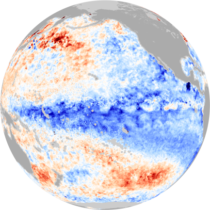
La Niña is in many ways El Niño running backwards. The trade winds strengthen, pushing warmer water farther out in the Pacific. Colder water, pulled up from the depths of the ocean, extends farther out into the mid-Pacific.

The darkest blue/brightest red represents water temperatures 5 degrees C cooler/warmer than average.
More cold water along the west coast of the U.S. means more cold air above it. This forms a blockade that effectively prevents storms carried by Alaskan winds from hitting California. La Niña brings dry conditions to the west coast of the U.S.
When it comes to droughts in California, La Niña is likely the culprit. And climatologists at the National Oceanic and Atmospheric Administration suggest that effects from a La Niña can linger for many years after that part of the weather cycle ends, compounding the effects of a drought.
When will a drought begin? When did it begin? Has it officially ended? These questions tend to be hard to answer, except for the data found in historical records. What’s for sure is this, however: Rain is good. Ignore the nursery rhyme!
------------------------------------------
Questions to ponder:
Why doesn’t a drought necessarily end after it rains? Why doesn’t a drought necessarily end after it rains for a long while?

