Rural Bolivia on the High Plains
Rural Bolivia on the High Plains
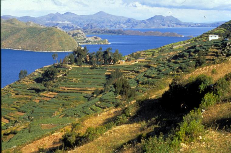
Lake Titicaca is located between two arms (known as Cordilleras) of the Andes mountain range (Occidental and Real), and is the reservoir for water from snowmelt in these high peaks. Such drainage has created a lake 3,100 miles2 (8,030 km2 ) large and more than 922 ft. (281m) deep, and is shared by the governments of Bolivia and Perú. At 12,493 ft. (3,808 m) above sea level Lake Titicaca is the highest navigable lake in the world, meaning that there is no other body of water at such altitude large enough for the passage of ships. Extending southward from Lake Titicaca is the Altiplano, a high, fertile plain, and the home to many indigenous peoples over time. Terraced fields, such as those in this photo, were built by pre-Incan civilizations to maximize arable land on the hillsides. Aymara speaking inhabitants of the island continue to cultivate a variety of crops on them, most notably potatoes. One of many other islands in the Lake (I. Luna, I. Taquiri, I. Paco, I. Calhuita), the Inca considered the Isla del Sol to be the navel of the world. Current residents still maintain these ideas, but are not completely disconnected from the mainland, as small fishing boats are available to transport people to nearby ports, like the one at Copacabana. From there the city of La Paz is only three hours away by bus.
Copyright Notice
©1996
Permission to reproduce any portion of the exhibit Urban Dreams/Suenos Urbanos is strictly prohibited.