Manifest Destiny
May 24 - July 2, 2021
Virtual Exhibition
As conservation and sustainability continue to become increasingly prominent in society, our understanding of how humanity has impacted the natural world over time has revealed a tragic past yet to be reversed. This exhibition will delve into the impact and legacy of Manifest Destiny in the western portion of the United States through a series of photographs. Images of both unknown locations and prominent regions are included to evoke a sense of responsibility and personal connection, but also reveal that harm is being done beyond our typical view. Photographs taken from 1938 to 1984 have been included from a variety of artists in hopes of making evident the legacy of Manifest Destiny as well as the detrimental impacts humans have had on the landscape of the United States. The de Saisset Museum provides a fantastic opportunity for this exhibition to be showcased to those who now reside in the region that has been taken advantage of throughout the history of the United States. For older generations, we hope the exhibition will reveal the damaging effects of the belief that nature is ours for the taking. For younger generations, especially those still at an impressionable age, we hope the exhibition will help them to see the past we must so desperately escape from. The idea that nature is humanity’s resource to exploit has long been ingrained in the mindset of Americans through the country’s capitalistic roots and inspired by Manifest Destiny. Our goal for this exhibition is that you, the viewer, are confronted with the legacy of Manifest Destiny and recognize that the time has come for America to break free from its problematic roots. It is time that we recognize our impact on the land and better our relationship with the American landscape.
Read the entire student essay: Manifest Destiny Essay
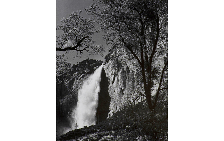
Ansel Adams, Yosemite Falls, Spring, Yosemite National Park, California, 1983, gelatin silver print, de Saisset Museum permanent collection, Santa Clara University, Gift of David B. Devine, 6.337.1986
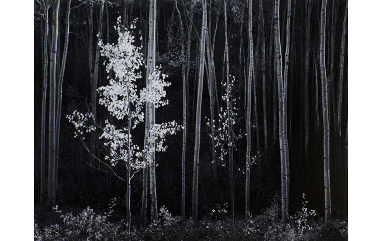
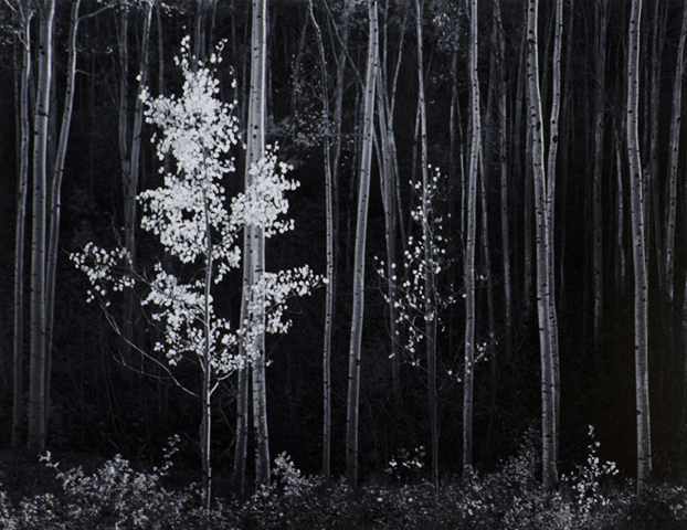
Ansel Adams, Aspens, New Mexico, 1958, 1958, gelatin silver print, de Saisset Museum permanent collection, Santa Clara University, Focus Gallery Collection, Helen Johnson Bequest, 6.4.1989
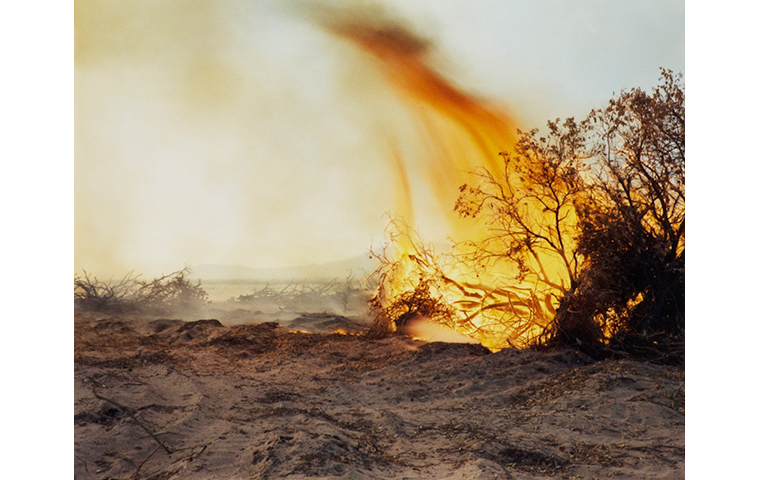
Richard Misrach, Desert Fire #77, 1984, chromogenic print, de Saisset Museum permanent collection, Santa Clara University, Gift of David B. Devine, 6.332.1986
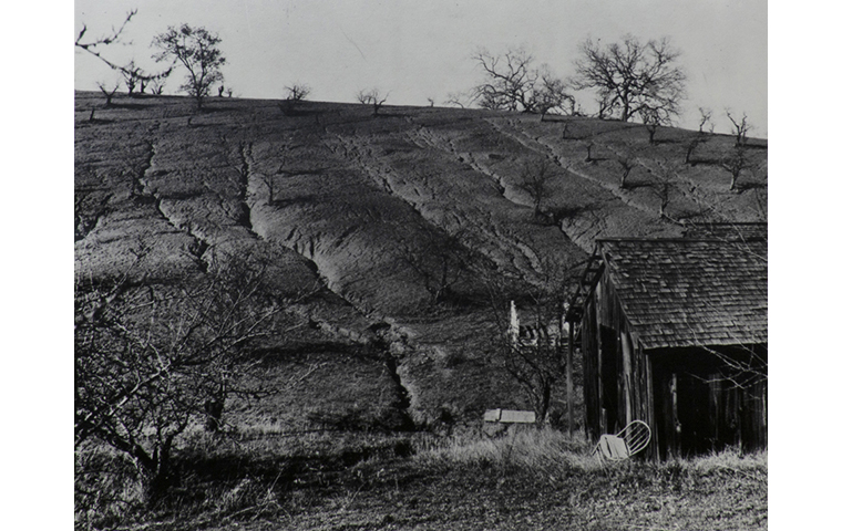
Unknown, Erosion destroyed hillside, 1/1/1938, 1938, black and white photograph, de Saisset Museum permanent collection, Santa Clara University, Purchased from Library of Congress, Washington, DC, USA, NDA.6.682
Erosion destroyed hillside, 1/1/1938
Unknown, Erosion destroyed hillside, 1/1/1938, 1938, black and white photograph, de Saisset Museum permanent collection, Santa Clara University, Purchased from Library of Congress, Washington, DC, USA, NDA.6.682
Given the date of this photo, we believe that it depicts the devastation of the land caused by the Dust Bowl. During the 1930s, almost all of the United States felt the effects of this event. Most historians agree that both natural and made-made causes are what lead to the desertification of the landscape during this period. The massive dust storms that gave the Dust Bowl its name were an effect of bad farming and watering techniques, as well as prolonged dryness and heat. In this image, you can see deep ruts in the hillside which are characteristic of erosion caused by excessive dryness and heat. The trees and other flora in the image also all appear to be dead or dying, which suggests that they have not received adequate water. American farmers were inspired by the ideals of Manifest Destiny and capitalism which led them to ravage the land through continual misuse. They saw the landscape as a source to be exploited; their greed is what drove their bad farming techniques. The Dust Bowl most heavily affected states in the Midwest, but it also affected those on the west coast. As the fertile farmlands dried up in the Midwest, farmers were forced to move out west in hopes of finding viable land. The dilapidated structure in this image is suggestive of this; it is possible that the owners left this land, after it dried up, in search of something farmable. Once on the west coast, the farmers did not stop their bad farming practices. In California, they had to heavily alter the landscape to transform it into adequate farmland. They also brought in crops that were not native to the landscape. Since this photo ended up in the de Saisset’s collection it likely depicts an orchard in California, possibly even in the Bay Area.
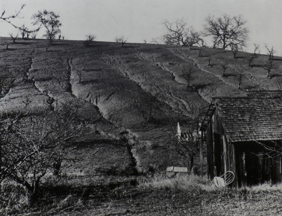
Shasta Dam, Shasta County, California. Construction work on the face of the dam, 6/1/1942
Russell Lee, Shasta Dam, Shasta County, California. Construction work on face of the dam, 6/1/1942, 1942, Library of Congress reprint on Agfa Portriga paper, de Saisset Museum permanent collection, Santa Clara University, Purchased from Library of Congress, Washington, DC, USA, NDA.6.699
In the face of the great depression, Americans across the country were left without work and money as they faced the most severe economic crisis of the decade. In hopes of sparking an economic revival and creating jobs, massive projects across the country were undertaken, including the development of many dams across the natural landscape. While many of these projects assisted in uplifting the people, they also had a tremendous impact on the environment. This image taken by Russell Lee during his time with the Farm Security Administration (FSA), shows one of these massive man-made structures dominating the landscape. Despite being considered a yes-man for federal bureaucracy, Lee considered himself to be a photographer and historian before anything else, and his images serve as a historical record of the events that occurred during his time in the FSA. Lee’s documentary photography of the Shasta Dam reveals the overwhelming prominence of human intervention in the natural world. In what would have once been a flowing source of water free of human presence, stands a massive manufactured structure that directly impacts the flow of nature. Despite the variety of benefits created by the construction of the dam, which would create California’s biggest reservoir, the structure directly imposes upon the natural systems in play. Lee’s documentary of the Shasta Dam project shows human intervention firsthand as it takes control over the natural environment for human gain. Even as the entire continent of North America becomes more populated, people continue to see the natural environment as a place meant for the taking.
Navaho Sacred Mountain of the East
Laura Gilpin, Navaho Sacred Mountain of the East, 1953, gelatin silver print, de Saisset Museum permanent collection, Santa Clara University, Focus Gallery Collection, Helen Johnson Bequest, 6.33.1989
Mount Blanca, or the Sacred Mountain of the East, plays an important part in the faith of the Navajo people. They view it as the starting point of their people and each member holds it dear to their heart. Every detail of the mountain correlates to a way for how they should lead their lives. Currently, the mountain stands as a natural heritage site in the San Luis Valley of Santa Fe, New Mexico. In 1953, Laura Gilpin captured this image of the sacred mountain in a landscape photograph. It depicts a large, arid, and completely barren valley leading up to the mountain which is primarily due to the effects of the Indian Termination Policy from the mid-1940s leading into the 1960s. This policy was established as a means to incorporate Native Americans into American culture, but that also meant that they would have to abandon their traditions. Although this seemed like a rather progressive move, what was put into practice was the forceful removal of the people from their lands. All of that information and mistreatment is completely invisible in this photo of the mountain. In spite of the fact that the Navajo people view it as sacred grounds with deep, spiritual meaning, it is cast as just another ordinary mountain in the eyes of the uninformed.
Note: Gilpin's original title for this photograph utilizes the spelling "Navaho."
Aspens, New Mexico, 1958
Ansel Adams, Aspens, New Mexico, 1958, 1958, gelatin silver print, de Saisset Museum permanent collection, Santa Clara University, Focus Gallery Collection, Helen Johnson Bequest, 6.4.1989
While the high contrast of this black and white image often leads the viewer to believe it was taken at night using flash photography, it was actually taken during the daytime. Compared to the sweeping landscape captured in Laura Gilpin’s image on the left, Navaho Sacred Mountain of the East, which also depicts a New Mexico landscape, the tight framing of this image makes the viewer feel like they are standing directly in front of the aspen trees. The high contrast and tight framing of this photo help convey Adams’ intention in taking this photo. Adams’ photography style blends together three traditional styles of landscape photography: view photography, survey photography, and the aesthetic landscape. Many of Adams’ iconic images, including this one, present the landscape in an aestheticized manner, but also have a documentary feel to them. His images are also intended to make the viewer feel awe towards the sublimity of nature. The traditional styles of landscape photography were all inspired by Manifest Destiny. Since Adams was inspired by these styles, his images are evidence of the legacy of Manifest Destiny and its continual impact on landscape photography. This is interesting to note because New Mexico is the first location an atomic bomb was tested during World War II. In fact, this image was likely taken near the Los Alamos National Laboratory which is responsible for designing said bomb. The dry, desert climate was the perfect test site for nuclear weaponry, which created the main source of income for the state’s economy. Los Alamos has continued to work with nuclear energy post-war and it continues to be the main source of income for the state. The testing of nuclear bombs and continued use of nuclear energy in the state has caused irreversible damages to the landscape, but Adams’ image does not refer to this. Instead, he presents the landscape as perfect and void of human effect in the spirit of the nineteenth-century landscape photographers who promoted Manifest Destiny.
Yosemite Falls, Spring, Yosemite National Park, California
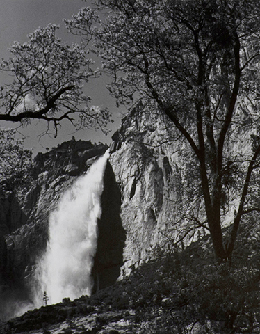
Ansel Adams, Yosemite Falls, Spring, Yosemite National Park, California, 1983, gelatin silver print, de Saisset Museum permanent collection, Santa Clara University, 6.337.1986
Ansel Adams, through his high contrast photography, displays a completely different intent from most other landscape photographers of his time. While other photographers were stuck on surveying the land with wide view shots, this photo of Yosemite Falls shows a highly aestheticized version of the site by having a tightened point of view. The trees cause your eyes to shift directly to the waterfall, which has an extremely high contrast between the water and its shadow. The sheer size of the waterfall brings a massive swell of astonishment to the viewer.
Adams commonly captures the aftermath of Manifest Destiny and the destruction left by it, but in this case, the documents Yosemite National Park as it is one of the earliest national parks in the United States dedicated to preserving the natural beauty of the land and showcasing its untouched state. It was made this way so that miners in the surrounding areas wouldn’t be able to tarnish the land in its entirety. During the prime of Manifest Destiny, not only was it one of the earliest to be founded, but Yosemite National Park was also one of the last few preserved landscapes in the entire country at the time. However, the news of a beautifully preserved park spread and caused a new wave of how the landscape is viewed, maybe not for the better. Now, with the increase in transportation capabilities as time goes on, instead of being a place of preservation and seclusion, people are able to visit the national park. The landscape has now been commoditized.
Desert Fire #77
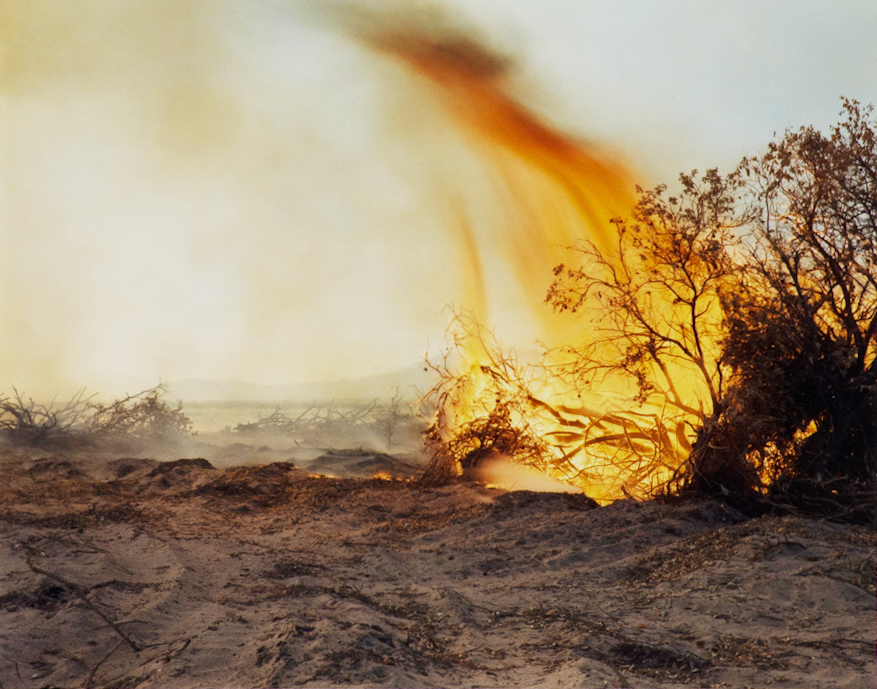
Richard Misrach, Desert Fire #77, 1984, chromogenic print, de Saisset Museum permanent collection, Santa Clara University, Gift of David B. Devine, 6.332.1986
Throughout his career, Richard Misrach has been at the forefront of documenting the horrific environmental effects of industrial development, chemical testing, pollution, and human intervention on the landscape. This particular photograph is a part of Misrach’s Desert Cantos series, which began in 1980 as a collection of images of destruction caused by military testing sites. This photographic collection intended to reveal the typically hidden destruction caused by humanity plaguing the natural world. Misrach’s style of cultural landscape photography can be seen vividly in this collection and specifically this image. This image shows a vivid depiction of the natural world literally up in flames. Although the background landscape is not the most profound, the environmental damage caused by humanity can be seen firsthand. In the background of the image, the hazy skyline created by the burning brush creates an orange hue engulfing the remnants of the destroyed vegetation in the distance. The ground in the forefront of the image depicts a chaotic desert ravaged by the influence of humans in the natural world. The viewer can see just a small portion of the untouched blue sky in the top right section of the image as the landscape has been almost entirely overtaken by the flames of destruction. This relatively simple photograph of a fire in the desert depicts the continuation of ideas of Manifest Destiny in the United States. Misrach reveals a firsthand account of how the government was destroying the natural environment beyond a typical public view.
Camp 3 at Lake Powell
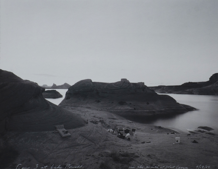
Mark Klett, Camp 3 at Lake Powell, 1984, gelatin silver print, de Saisset Museum permanent collection, Santa Clara University, Gift of David B. Devine, 1991.2.6
Inspired by his Rephotographic Survey Project from the 1970s where he revisited sites photographed during the nineteenth-century surveys of the American West, artist Mark Klett started his Revealing Territory series. This project was intended to present an updated survey of the west that showcased the legacy of Manifest Destiny. This photograph, and the others from this project, are intended to reference both the style and subject matter of the earlier survey images. During the nineteenth-century survey photographers such as Timothy O’Sullivan and William Henry Jackson took images of the landscape that embody the ideals of Manifest Destiny. Most of their images do not include humans but are suggestive of humans' dominance over the land. In opposition to this, Klett purposely includes humans' presence in the landscape to directly reference human exploitation of American landscapes and call attention to the legacy of Manifest Destiny. Taken during a trip to Lake Powell, Klett utilizes his camp setup to alert the viewer to humans' presence and effect on the landscape. Lake Powell is one of the largest man-made reservoirs in the United States. It was created as a result of the construction of the Glen Canyon Dam in the Arizona portion of the Colorado River in 1963. When a dam is constructed, the builders “tame” the wild landscape and force it to follow their will. This embodies the idea that the American landscape is to be dominated by man and used for their benefit, which is promoted by Manifest Destiny. This image, and the others in the series, make apparent the lasting impact and legacy of Manifest Destiny in the western portion of the United States.
Envisioned Installation Layout
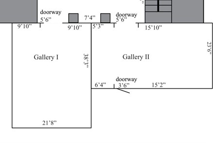
Gallery II:
Wall 5’3”
Ansel Adams, Yosemite Falls, Spring, Yosemite National Park, California, 1983
Keeping social distancing in mind, this image is intended to be viewed near Laura Gilpin’s image on the right. Both images are characteristic of traditional landscape images that were influenced by the ideals of Manifest Destiny. The viewer is expected to view these images first in order to contextualize later images in the exhibition.
Wall 15’10”
Laura Gilpin, Navaho Sacred Mountain of the East, 1953
As previously stated, this image is intended to be viewed in close proximity to Ansel Adams’ image of Yosemite Falls. It should also be viewed near Adams’ image of the aspens and Richard Misrach’s image of fire. This image and Adams were taken in New Mexico and follow the style of traditional, nineteenth landscape photography.
Wall 23’6” (right)
Ansel Adams, Aspens, New Mexico, 1958
Richard Misrach, Desert Fire #77, 1984
Misrach’s Desert Fire #77 depicts a fire caused by military testing of weaponry in the landscape. By placing it next to Adams' image of the aspens we are able to call attention to the destruction he ignores. The first atomic bomb was dropped in New Mexico, but both images focus on the beautiful, unaltered, landscape. By placing the images by Misrach, Adams, and Gilpin in close proximity we begin to shed light on the legacy of Manifest Destiny.
Wall 15’2”
Unknown, Erosion Destroyed Hillside, 1/1/1938, 1938
We’ve placed this image next to Misrach's image because, at first glance, it appears to depict the opposite of humans' effect on the landscape. The viewer might assume that this image only depicts the effects of drought, which is a natural and uncontrollable phenomenon. With their new awareness of the effects, humans inspired by Manifest Destiny had on the landscape, we suggest to the viewer that this image is evidence of this as well.
Wall 23’6” (left)
Russell Lee, Shasta Dam, Shasta County, California. Construction work on face of the dam, 6/1/1942, 1942
Mark Klett, Camp 3 at Lake Powell, 1984
These images are placed next to each other as well as near Adams’ Yosemite Falls and Unknown, Erosion Destroyed Hillside in order to show how far humans have come in attempting to control the landscape and effectively perpetuating the legacy of Manifest Destiny. When viewed next to the image of the eroded hillside, the viewer can see the positive and negative outcomes of human manipulation of the natural landscape. When viewed next to Adams’ image of Yosemite Falls, the viewer can better understand how Adams’ image insidiously references Manifest Destiny.