September 2014 Maker of the Month Winner
Nicholas Xydes
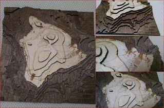
Topographic Map of the Island of Hawaii
Laser Cutter and Basic Tools
Nicholas Xydes, graduate student, created a topographic map of the Island of Hawaii out of wood. He collected GIS data on elevation and used Google Maps for the roads. He then created the topographic map showing both elevation in 1000m increments and all roads on the island. The laser cutter was implemented to raster the roads and cut each level to shape. Basic tools were utilized to sand, stain, glue and clamp the layers together.
Dec 18, 2015